uk3peaks.com
uk3peaks.com |
Mountain: Total Ascent:
4,495 ftStart:
(alternate start - Glen Nevis Youth Hostel)Distance:
10.1 milesMap: Target Time:
GPS Route: Download GPX file [right click to "save as"]
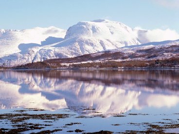
Ben Nevis from across Loch Linnhe - there may be snow still in the summer, but probably not this muchYou should be in no doubt that even in summer the weather at the summit can be cold, wet and cloudy. The average summit temperature is aorund -0.5°C, and there is over twice as much rainfall every year at the summit then at the foot in Fort Wiiliam. You will be lucky to have a cloud free summit.
For 21 years there was a constantly manned obervatory on the summit, the ruins of which are still there. The popular tourist path was made at the same time the observatory was opened to allow ponies to bring supplies to the observatory, hence the name Pony Track.
When you are struggling up and down Ben Nevis and hopefully get a good time remeber that there is an annual Ben Nevis race in September where the record to the top and back is 1hr 25mins.
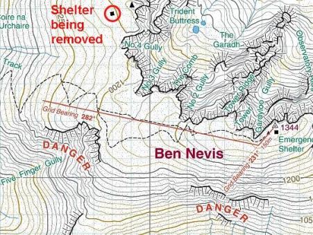
Summit Safety
You should be aware that navigation around the summit area of Ben Nevis can be very dangerous when there is low visibility due to the proximity of the steep cliffs of the North East Face and also of Five Finger Gully the south western side.
In order to safely acend from the summit the safest way is to go 150m on a bearing of 231° from the summit carin. You should be aware of Gardyloo Gully on your right hand side on this section. Then take a bearing of 282° where you will travel around 300m on a farily flat section, followed by a steeper section for 100m after which the angle eases.
You should eventually hit the zig-zag path which you can then follow safely down.
Map of the summit area of Ben Nevis
The two popular times for starting Ben Nevis are around 5-6am or around 4-5pm. We decided on the later start. Most people start from the Glen Nevis Visitors Centre which is on the Glen Nevis road. Alternatively you can start from the Youth Hostel which is further along the Glen Nevis road. The Youth Hostel start and finish gives a shorther route overall (probably about 1 mile) but involves a steep initial climb of around 180m in less than 500m horizontal to meet up with the Pony Track. The Visitors Centre path provides an easier first half-an-hour of the walk and allows your body to warm up for the walk. Perhaps the best way is a combination of the two where you start at the Visitors Centre and finish at the Youth Hostel. In order to do it this way you will have to work out a way of ensuring your driver is at the Youth Hostel when you arrive back down.
Route
Once you have reached the point at which the Visitors Centre and Youth Hostel paths meet the path is the same all the way up.
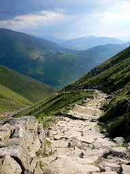
Well defined Pony Track
Once passed the turn there is a long failry straight section of just over 1km at which point the path starts to zig-zag up towards the summit. At around 1200m there is a choice of whether the follow the final zig-zags up to the summit plateau or to head staright up through the scree. You will probably have to judge how you are feeling at this point to decide which path to take, and also whether you prefer to stay on the Pony Track which is easier walking than the scree.
At the summit you will see the ruins of the observatory, a first world war memorial, an emergency shelter, and a summit cairn with a trig point on top.