uk3peaks.com
uk3peaks.com |
Mountain: Total Ascent:
PT - 777 m / 2,550 ft
Start: Distance:
PT - 10.5 km / 6.5 milesMap: Route Map
- Miners' Track
Route Map
OS Explorer map 17 - buy map
Target Time:
GPS Route: Download GPX file - Miners' Track [right click to "save as"] Download GPX file - Pyg Track [right click to "save as"]
Start
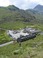
The start point for either the Pyg Track or the Miners Path is the car park at Pen-y-Pass. There are toilets and a café next to the car park. However, the car park gets very busy and it is more than likely to be full when you arrive. You must therefore be prepared to pull up and jump out with your driver then moving off to somewhere else straight away. There is a drop-off area next to the road specifically for this.
Summit of Snowdon from Llyn LlydawThe two obvious places your driver can go are to Nant Peris where there is a large free car park area on the left as you enter from the Pen-y-Pass direction. There is also a pub in Nant Peris called the Vaynol Arms
where they can go for something to eat. Alternatively they can head to Llanberis where there are car parks and pubs mainly for the many tourists who come to use the train up Snowdon.
One tip worth remembering for any practice walks you might do is that it is far easier to park at Nant Peris and catch the fairly frequent Sherpa Bus
These are the two most popular routes up Snowdon both starting from Pen-y-Pass. Both have advantages and disadvantages which I have listed below. I have also described both paths below, and if you do go for a training walk to Snowdon you can try both to see which you prefer. One option is to do a combination of going up one and down the other.
Pen-y-Pass car park Shorter path overall
If you choose the Miners' Track then head for the gate at the South end of the car park, the left hand side if you have your back to the road. The Miners' Track for the first few miles has a broad gravel type path which is level or only gradually rising. This path will allow you to warm up after being cramped in a car or minibus for the last few hours. If your tight for time, or feeling good, you can always jog along to make up for the longer walk than on the Pyg Track.
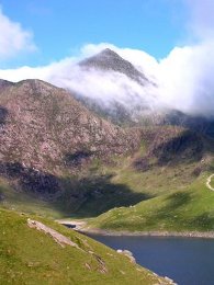
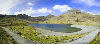
Miners' Track at the edge of Llyn LlydawThe path contours around the small hills near to Pen-y-Pass and crosses a causeway over Llyn Llydaw. About 1 km further on the path breaks away from the side of Llyn Llydaw and starts a steeper climb from about 400m to 600m at Glaslyn. All along the path you will pass abandoned mines which used to extract copper, and it is because of the copper deposits that Glaslyn and Llyn Llydaw have a blue tint.
The path then continues climbing until you reach a long marker stone where it meets with the Llanberis path. The last short section for around 700m is along the ridge and following the railway up to just below the summit and behind the new café which is currently being built. You should not walk on the railway tracks as this causes erosion on the track bed. Below the rocky summit are two short stairways either side which you take up to the trig point at the top.
Returning along the Miners' Track is relatively easy once you have descended to Glaslyn. Remember to turn right at the long finger stone off the Llanberis path, and also at the boulder at the top of the Miners' Track. The descent down the steep part to Glaslyn can be tricky especially when the rocks are wet from rain. Walking poles certainly help here to give another point of contact and to steady your balance. The Miners' Track gradually widens out and becomes less rocky and more flat as you get closer to Pen-y-Pass. If you are really pushed for time then it is certainly possible to jog along the Miners Track from the side of Glaslyn all the way to Pen-y-Pass if you still have the energy left.
Pyg Track
The Pyg track starts at the Western corner of the Pen-y-Pass car park (on the right if you have your back to the road). The Pyg Track has short flat sections, but for most part is a constant climb. In fact, you will start climbing as soon as you leave the car park with no chance of an easy flat warm-up. This may influence your decision on which path to tack, especially as Snowdon is the last mountain of the three when you may be feeling most tired.
The path is fairly well defined and meets up with the Miners' Track just before the steepest section to come up to the Llanberis path ridge and the railway. Once you meet the Llanberis path the rest is as described for the Miners' track of following the railway to the summit.
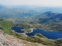
Looking down on the Miners' path from Pyg
The other path which some three peaks walkers take to the summit is the one starting at Llanberis and following the railway. This path is easier overall but it is also longer than either the Pyg or Miners' at about 10 miles return. Some walkers go up the Pyg or Miners' and come down this path which is easy to o run down in order to meet their driver back at Llanberis. We looked briefly at the Llanberis path but decided it was simply too long so I have not described it in any detail here, but there are links to websites with information on this path in the links section of this website.
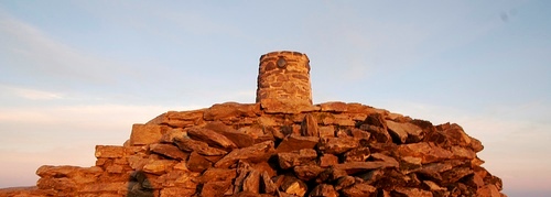
Snowdon Summit Cairn