uk3peaks.com
uk3peaks.com |
Mountain: Total Ascent:
2,995 ftStart: Distance:
5 milesMap: Target Time:
GPS Route: Download GPX file [right click to "save as"]
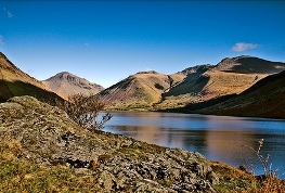
Wastwater with Scafell Pike second from right
You can choose to start the walk up Sacfell Pike from either Wasdale Head Green or from the start of the track which leads to the National Trust car park and campsite. I have walked from both points and starting from the campsite road is the slightly shorter and quicker route. The National Trust car park next to the campsite does not open until 7.30am and therefore if you are on a typical schedule and start before then your drivers will have to drop you off at the top of the track and then park up on the Green anyway. There are a few small lay-bys next to the start of the campsite track, but it is likely they will be full when you arrive, so be prepared to jump out and get going when you arrive.
Route
Most of the route is on well defined rock and stone paths. From the campsite you will be constantly climbing for the majority of the route, with very few flat sections. You will meet up with the path from Wasdale Head Green just over 1 km in to the walk, and immediately pass through a gate. Beyond this you will need to cross the stream which feeds in to Lingmell Gill and it is very likely that you will get your feet wet. This crossing may become dangerous after lots of rain. Walking poles to help with your balance would be useful for the crossing. I found the best way across was to aim for the shallowest and calmest section and simply walk though. With a good pair of boots you should avoid getting wet.
As you get towards the saddle between Scafell Pike on your right and Lingmell on your left you will follow the path to the right for the final section of the climb. There are lots of cairns around the path at this stage, but as the landscape becomes increasingly rocky it can be easy to lose the path and start heading in the wrong direction.
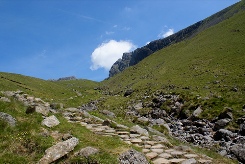
Looking up the path along Brown Tongue
Heading down should be quicker, and certainly when you get to the well defined path after Hollow Stones it is very difficult to get lost. It is possible to jog down certian sections of the path as you come down, but it shouldn't be necessary to do so. After the stream crossing the only choice is whether to descend to the campsite or the Green as the path splits.
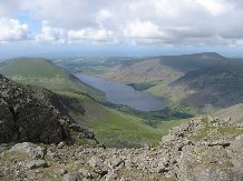
Looking down on to Wastwater
People doing the three peaks have become increasingly unpopular in Wasdale Head due to the numbers turning up pre-dawn during the summer months. Wasdale Head has very limited toilet facilities, and no mains water. You should be prepared to bring your own water supplies, and try to reduce the nuisance you cause by doing the challenges in small groups making as little noise as possible.
Also, if you are on the typical schedule of starting Ben Nevis at 4-5 pm, you will start Scafell Pike and complete most of the climb in the dark. You therefore need to ensure everyone in your team has headtorches with spare batteries, and knows how to use them. If you are climbing Scafell Pike in the dark, it is highly recommended that you do at least one training walk here so that you are familiar with this route.
An alternate route to Scafell Pike is via Seathwaite which is north east of the summit and which you can get to via the Sty Head Pass and Corridor Route. There is some debate as to whether this is a better route. The main advantage is that access to Seathwaite is easier from M6 J40, A66 and B5289, and it is likely you will save possibly 30 mins to 1 hour overall driving time. However, the drive out from Seathwaite either involves heading back north along the A66 to the M6, or a long drive to Ambleside and out via the A591. Another disadvantage is that the Seathwaite route involves around 2-3 miles extra walk, so you are likely to loose any advantage you have from the shorter drive.